Capture and the map
Finishing a session turns part of your route into ground you hold. One cell per session, and the map keeps the record.
The cell grid
The map is a grid of hexagons. Every point on it falls inside exactly one cell, and a cell is the smallest piece of ground you can hold.
Hexagons rather than squares because each one borders six neighbours at an equal distance. Ground spreads outward evenly, and there are no awkward diagonal corners where two cells meet at a point.
Cells in the current build are roughly 300 metres across. The grid is generated on your device, so the same street always resolves to the same cell for you. Moving to a shared global grid, where the same corner is the same cell for every player, is planned and is what districts and clubs are waiting on.
What one session claims
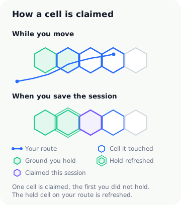
Your route passes through a run of cells. When you save the session, the app walks that list in order and claims the first one you do not already hold. That is one new cell per saved session, however far you went.
The rest of the touched cells are not wasted. Any that you already hold have their hold refreshed, which is the main way ground stays yours. A long route through your own neighbourhood might claim nothing new and still be the most useful session of the week.
A session has to cover 200 metres or last five minutes before it can be saved at all. Below that it is treated as noise rather than a walk.
One claim a day
Saving is limited to one session per calendar day. A second session that day still records and still shows you its summary, and it will not claim a cell or refresh a hold.
The limit exists so the map rewards a habit rather than an afternoon. Someone who walks once a day for a month ends up with far more ground than someone who walks six times on a Sunday.
What the map shows
The territory map is the running record of everything you hold. Each cell is drawn in the state it is currently in, so you can see at a glance which ground is solid and which needs a visit.
| State | What it means |
|---|---|
| Yours | Held and defended. Nothing needed. |
| At risk | Your hold has drained low. A visit restores it. |
| Contested | Left long enough that the hold is gone and your grip is slipping. |
| Dormant | Neglected long enough to drop off. Walking it again brings it back. |
Tapping a cell opens its detail view: how long you have held it, when you were last there, how strong your hold is, and what to do next. The numbers behind those states are set out in Holding your ground.
Cell names
Cells carry short names like Riverside Loop or Signal Yard. They are generated from the cell's own identifier, so a given cell always shows the same name and it stays the same for as long as you hold it. They are labels for your own map rather than real place names, which is deliberate: the app never resolves your position to a real address, neighbourhood or landmark.